Custom Mapping Tools

Below are a few online tools that you can use to create custom maps for free on your own computer and print at home or use a commercial printing company.
Trail or Park Maps
You want to explore Allegheny County's nine spectacular parks, and you want to take a paper guide with you? Then you should visit the Park Trails Web Tool to access an application specifically created to complement the County's Trails mobile app. The trails app can be downloaded on Apple and Android. It includes up-to-date trail data, as well as contours, shelters, parking lots, and other park amenities. The application's side panel has detailed instructions on how to utilize this tool.
Other Maps
You need a physical map of your parcel boundaries, voting districts, or other regional amenities? Then you should visit the GIS Data Viewer. Like the Park Trails Web Tool, you can annotate, draw, measure, and print your map using the widgets on the right pane. In addition, you can change each dataset's visibility, transparency, and/or order within your map.
If you want to create a parcel or boundary map, possibly with addresses, elevation, and other nearby amenities, pan the map or use the search bar to zoom into your Address or Parcel ID (###-X-###). This is the same ID as in your tax bill, but without the zeros. Please note the disclaimer on the splash screen. If you need exact parcel boundaries, contact a Land Surveyor.

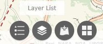
If you would like an election, school district, or zip code map, you can easily "turn on/off" this data using the Layer List widget (the second widget on the bottom pane of the GIS Data Viewer).
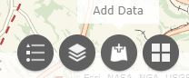
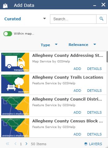
For other datasets, like WIC vendors or the region's watershed, you can use the Add Data widget (the third widget on the bottom pane of the GIS Data Viewer).
And then choose from the County's catalog of GIS Open Data.
Contact
Feel free to contact us if you have inquiries about other datasets.